Thursday, September 9, 2010

Such Great Heights


For a city of its size, there isn't really an iconic view of the Philadelphia Skyline. We don't have "the" view, in the way that New York has Lower Manhattan on postcards everywhere. There are many possible reasons for this, but I think that a big one is logistical- it's not easy to view the whole city at once. Long views are often taken from the water, but we don't have an Ocean, a Bay, or a Great Lake at our disposal. The Delaware River, as we know all too well, is too much of a commercial waterway to really be useful here. Coming in on the train from the NE corridor is picturesque and flattering, but the view only lasts for a few seconds before you are sucked underground. Philly also doesn't have a skyscraper lookout point, either- the highest publicly accessible location is still City Hall.

Don't look down

In this context, then, the extreme popularity of roofdecks makes a lot of sense. I am not one of lucky (yet), but I was up on my rowhouse roof last week, and was stunned by what I saw. From 3 stories up in G-Ho, er SWCC, er...Fake South Philly, I could see all the way from river to river, and a little of UCity, as well.

Society Hill Towers (right background) and the Pepto Bismol condo :

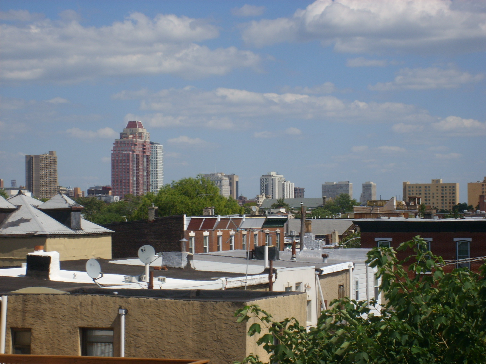
To the Drake and the Rittenhouse Skyline:

The West Market Skyscrapers:


Perelmen Center for Advanced Medicine:

Endless rowhome roofs:
And finally, my block.


Of all these, the West Market view is probably my favorite. It contains all of the city's tallest buildings, and catches them at a diagonal angle, giving the skyline some depth (as opposed to the famous view from the East, which seems "flat" to me, like set dominoes).
Photographers may recognize this as the unavailable "South Street Bridge View", as well. For another few months, the tops of our own houses are the best replacement.

Friday, August 27, 2010

Fill in the blanks

Philadelphia's Center City District (CCD) just released ashort report on biking statistics in the city, and the results, while common sense, are worth repeating. In summary:

1. Bikers like to use bike lanes
2. Philly needs more of them
3. A few streets with well laid out and maintained cycling lanes is good for both bikers and drivers

Again, nothing shocking, but it's nice to make these arguments with the benefit of solid data for once. It's also nice to a neutral party weigh in, instead of the angry back and forth that goes on between, say the Inquirer's Stu Bykofsky and the cycling advocate groups.


The two illustrations in the report caught my eye. The first points out that northern travel is highest on 22nd street, undoubtedly because it has a dedicated bike lane. Interestingly, the next street over had the lowest number of riders, suggesting that cyclists will change their route to seek out safer streets. This part is where drivers should pay attention: it means that giving up a few lanes of traffic for bike lanes means that the rest of the streets will have fewer riders on them, making it easier and safer for everyone.

The report ends with a map of the bicycle lanes in Center City. It's not bad, but the network contains gaps that are begging to be filled in. Using Google Maps to calculate distances, you can go from the existing grid,


to a much more useful one like this:


just by adding a little more than one mile of lanes (the yellow lines). If you are willing to add 2 more miles (in blue), you can end up with a total "loop" that encompasses Center City. Early bike lanes in the city were chosen by where it was easy to put down a lane, rather than where they were needed. The lanes on Pine and Spruce Streets were and are a big deal, but until the network is actually tied together, all of the individual lanes become less valuable. It will take political willpower to fill in the gaps, since it involves taking away either a driving lane or parking spaces. If the end result is a city that is safer for cyclists and better for drivers, though, surely that's not too much to ask?

Monday, August 16, 2010

Alternate Plans


It seems fitting that a main detour for the South Street Bridge actually is very similar to its departed cousin. The 34th Street Bridge, which connects University and Grays Ferry Avenues, is one of several old city bridges that puts the newer Walnut and Chestnut St. bridges to shame.

Dating back to 1929, it was built as a drawbridge just like the South St. Bridge; however, unlike the SSB, it was never permanently closed.
Don't look down
A phillyhistory.org photo shows that the bridge has changed very little since its opening- the same, fortunately, cannot be said about the surrounding land.


For now, the bridge serves as a detour for people in Point Breeze and lower G-Ho to get to University City and the Hospitals (and, y'know, jobs); it also is the fastest way to and from I-76. Sadly, the bridge currently has zero (0) SEPTA buses that run across it. This is especially sad when you consider that Point Breeze is finally starting to show some life, and that the bridge could be a connector between the two neighborhoods. My guess is that the 34th Street Bridge will become heavily used right around the time it needs to be replaced. Then, of course, we will be greeted with signs pointing us to the new, improved South Street Bridge:


which, of course, looks a little like a cheaper, uglier version of an old bridge.

More views:


Western side

city skyline

I-76 bridge

the banks below

Wednesday, August 11, 2010

Before and After


Sometimes, events are only important in retrospective.

In 2006 or 2007, the house at 2301 Catharine St. was bought, gutted, and covered up. This raised no eyebrows; it was and is a common occurrence in G-Ho. It was what happened next that surprised. Nothing. No buzz and noise of construction, no gleaming new rehab to sell at a tidy profit. Only a small notice of foreclosure that was eventually stapled to the door gave a clue to what had just happened. Then, for almost 3 years, the shell decayed (remembered, for now, by Google Maps), while around it, the entire world got a lesson in foreclosures and subprime mortgages.

Around the time I took these pictures, I listened to Malcolm Gladwell read his essay on US intelligence called "Connecting the Dots." In it, he references "creeping determinism", which is, in his words,

"the sense that grows on us, in retrospect, that what has happened was actually inevitable--and the chief effect of creeping determinism, he points out, is that it turns unexpected events into expected events. As he writes, "The occurrence of an event increases its reconstructed probability and makes it less surprising than it would have been had the original probability been remembered."


Should this house been a tip-off to what was coming? Should people who bought at the market peak have known better? Maybe, although Gladwell might not be so sure.

Fortunately, the story of this house, unlike the country as a whole, has a happy ending. Earlier this year, work finally started, and a few weeks ago, a very, very large banner appeared on the side of the house. 'Hood house prices are down slightly, but nowadays that's actually a major positive, and they will probably start to rise again soon. In the meantime, there is one less shell on Catharine Street, and at least a few more neighbors. In the end, 2301 may end up serving as a canary twice- once, to signal the start of the crash, and hopefully again, as the beginning of the way out.


Edit: Thanks to LB and Jayfar, here is how the house looked in 2007, and back in 1960. And yes, the fake brick window thing is horribly ugly, but for this particular house I can't get too mad about it.

in 2007

In 1960

Friday, July 30, 2010

Out of Town

This space will be quiet for the next week, as I will be in the midwest taking some time off and visiting family. To tide you over, I'll give you a quick story.

When back in Michigan (where I went to college and Mrs. Redbricker was born and raised), we often stay at the in-laws, a few miles north of Ann Arbor. Now, before I go on, I feel the need to say that I actually get along very well with them, and always have a good time there. This may have something to do with the fact that my father-in-law is only able to express affection by saying "you don't have a beer in your hand. Let me fix that", but I digress. The point is, they live in a newly created subdivision, and on occasion will unwittingly show everything that is wrong with the suburbs.


Example: My in-laws live at point A. My brother-in-law used to live at point B. To visit, they would get in the car and drive the .6 miles to each others' house. This happens even in the summer, when it's nice out, even though the road is 3 times as long as cutting through the field behind the street. A rough guess is that walking is 12-1300 feet, while .6 miles converts to somewhere north of 3100 feet.


It would be easy to make fun of my new family as "lazy", but that would miss the point. Whoever made the subdivision decided not to put sidewalks in some places (the first section of our trip), and also did not connect the trail to the dead-end street, leaving all but the most die-hard walkers an easy choice to drive. I don't think it's a coincidence that I gain 5 pounds every time I visit this place.

Fortunately, the cul-de-sac's days may be numbered, for both practical and aesthetic reasons. Read about it here, in a great post at the Infrastructurist.

Tuesday, July 27, 2010

One Hundred Years


I grew up in the heart of Northern Jersey Suburbia.


The town of Randolph essentially didn't exist until the 1970s- it was all farmland before then- and even now is 95% residential subdivisions, spiraling off into the hills. Because of this, I am acutely aware of the abundance of old buildings in this city, ones that date back a hundred years or beyond. Old schools and churches that would be the centerpiece of an entire small town are found around nearly every corner, hidden away without fanfare. For proof, I have to look no further than literally out my front door, to the St. Anthony's Senior Center.


This multi-story monument is a great example of what can be accomplished using only brick. It's like the decorative Philly rowhomes of old, writ large. Sadly, it's hard to find much (any) information about the building- all I know is that it had at least one previous life, as a parochial school in the early 20th century. Even this I only know because it's actually part of the building.


A large and almost empty parking lot also points to a busier past, but for now, it is a quiet retirement community. Thankfully, the surrounding yard is immaculately maintained, and shows no signs of neglect, even though the buildings managers don't even see fit to mention the property on their web site.
There are no pictures of St. Anthony's on Philly History. That's probably OK, as I can't imagine it looking much different- you'd have to look at tree sizes to see a difference. Still, the entire estate is in wonderful shape, and looks like it could easily last for another century.


As you read, enjoy a little music from our biggest Philly band, Dr. Dog:


EDIT:
Check out the comments for some more great information. Apparently, the school was a part of the St. Anthony's Parish, which was located in what is now St. Matthew's Baptist Church.

Monday, July 19, 2010

Last Train to Chester


Like a lot of people (OK, at least 18,000), I was excited to learn that Philadelphia had been chosen as the new expansion side for MLS back in 2008. However, like a lot of people, I was concerned about the stadium location on the Chester waterfront. Not because of safety issues, but for accessibility. Part of the fun of living in a big city is taking public transit to games, and not worrying about parking (or drinking).

Fortunately, two years later, I can safely say that taking the train to a Union game is not only doable, it is recommended. What follows is a photo essay from a murderously hot day soaked in beer, sweat and victory.


My trip started at the University City Station. During the week, this relatively new station (it opened in 1995) is a crowded, busy station, filled with commuters who work at HUP, Penn and CHOP. During the week. At lunch time on a Saturday, it's less vibrant.


Happily, 2 hours before kickoff, the R2, er, Wilmington, er Marcus Hook Train was completely filled, and about 90% of the train got of at the Chester Transportation center.


This is where the hyper-competent Union front office kicks in. Waiting for us is a fleet of shuttle buses, which will zip us through the city and drop us off a few feet from the stadium.


This side is surrounded by half-completed ramps to the bridge, but the other side...


Did I mention a bridge? The Commodore Barry looms over the stadium, and a walk by the river
reveals some stunning views:


Inside the stadium, it's just as nice. The seats are really, really close to the field, and catching an errant shot is a real possibility:


The game was tense, and tied 1-1 until almost the last second, when a Toronto player committed a handball in the penalty area. That led to this (video courtesy of my row-mate Billy):


Maybe Apple should use this video in a promotion- the iPhone gets knocked out of Billy's hand and flies a few feet away, but keeps recording the whole time and is unscathed at the end.

After the game, there is a bit of a walk back to the buses, and then a line, which seems longer that it actually is after standing in 95 degree heat for a few hours. These gentlemens' spirits did not seem dampened once on the train though, and after about 25 minutes, I'm back to where it all began.

Only two weeks until the next game.