Friday, August 27, 2010

Fill in the blanks

Philadelphia's Center City District (CCD) just released ashort report on biking statistics in the city, and the results, while common sense, are worth repeating. In summary:

1. Bikers like to use bike lanes
2. Philly needs more of them
3. A few streets with well laid out and maintained cycling lanes is good for both bikers and drivers

Again, nothing shocking, but it's nice to make these arguments with the benefit of solid data for once. It's also nice to a neutral party weigh in, instead of the angry back and forth that goes on between, say the Inquirer's Stu Bykofsky and the cycling advocate groups.


The two illustrations in the report caught my eye. The first points out that northern travel is highest on 22nd street, undoubtedly because it has a dedicated bike lane. Interestingly, the next street over had the lowest number of riders, suggesting that cyclists will change their route to seek out safer streets. This part is where drivers should pay attention: it means that giving up a few lanes of traffic for bike lanes means that the rest of the streets will have fewer riders on them, making it easier and safer for everyone.

The report ends with a map of the bicycle lanes in Center City. It's not bad, but the network contains gaps that are begging to be filled in. Using Google Maps to calculate distances, you can go from the existing grid,


to a much more useful one like this:


just by adding a little more than one mile of lanes (the yellow lines). If you are willing to add 2 more miles (in blue), you can end up with a total "loop" that encompasses Center City. Early bike lanes in the city were chosen by where it was easy to put down a lane, rather than where they were needed. The lanes on Pine and Spruce Streets were and are a big deal, but until the network is actually tied together, all of the individual lanes become less valuable. It will take political willpower to fill in the gaps, since it involves taking away either a driving lane or parking spaces. If the end result is a city that is safer for cyclists and better for drivers, though, surely that's not too much to ask?

Monday, August 16, 2010

Alternate Plans


It seems fitting that a main detour for the South Street Bridge actually is very similar to its departed cousin. The 34th Street Bridge, which connects University and Grays Ferry Avenues, is one of several old city bridges that puts the newer Walnut and Chestnut St. bridges to shame.

Dating back to 1929, it was built as a drawbridge just like the South St. Bridge; however, unlike the SSB, it was never permanently closed.
Don't look down
A phillyhistory.org photo shows that the bridge has changed very little since its opening- the same, fortunately, cannot be said about the surrounding land.


For now, the bridge serves as a detour for people in Point Breeze and lower G-Ho to get to University City and the Hospitals (and, y'know, jobs); it also is the fastest way to and from I-76. Sadly, the bridge currently has zero (0) SEPTA buses that run across it. This is especially sad when you consider that Point Breeze is finally starting to show some life, and that the bridge could be a connector between the two neighborhoods. My guess is that the 34th Street Bridge will become heavily used right around the time it needs to be replaced. Then, of course, we will be greeted with signs pointing us to the new, improved South Street Bridge:


which, of course, looks a little like a cheaper, uglier version of an old bridge.

More views:


Western side

city skyline

I-76 bridge

the banks below

Wednesday, August 11, 2010

Before and After


Sometimes, events are only important in retrospective.

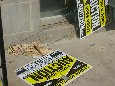
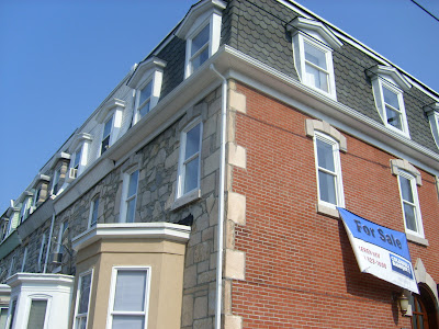
In 2006 or 2007, the house at 2301 Catharine St. was bought, gutted, and covered up. This raised no eyebrows; it was and is a common occurrence in G-Ho. It was what happened next that surprised. Nothing. No buzz and noise of construction, no gleaming new rehab to sell at a tidy profit. Only a small notice of foreclosure that was eventually stapled to the door gave a clue to what had just happened. Then, for almost 3 years, the shell decayed (remembered, for now, by Google Maps), while around it, the entire world got a lesson in foreclosures and subprime mortgages.

Around the time I took these pictures, I listened to Malcolm Gladwell read his essay on US intelligence called "Connecting the Dots." In it, he references "creeping determinism", which is, in his words,

"the sense that grows on us, in retrospect, that what has happened was actually inevitable--and the chief effect of creeping determinism, he points out, is that it turns unexpected events into expected events. As he writes, "The occurrence of an event increases its reconstructed probability and makes it less surprising than it would have been had the original probability been remembered."


Should this house been a tip-off to what was coming? Should people who bought at the market peak have known better? Maybe, although Gladwell might not be so sure.

Fortunately, the story of this house, unlike the country as a whole, has a happy ending. Earlier this year, work finally started, and a few weeks ago, a very, very large banner appeared on the side of the house. 'Hood house prices are down slightly, but nowadays that's actually a major positive, and they will probably start to rise again soon. In the meantime, there is one less shell on Catharine Street, and at least a few more neighbors. In the end, 2301 may end up serving as a canary twice- once, to signal the start of the crash, and hopefully again, as the beginning of the way out.


Edit: Thanks to LB and Jayfar, here is how the house looked in 2007, and back in 1960. And yes, the fake brick window thing is horribly ugly, but for this particular house I can't get too mad about it.

in 2007

In 1960